Africa
Africa technology to bridge the energy gap
We are still far from achieving universal access to electricity. Innovative solutions and technologies, such as geographic information systems and artificial intelligence, can improve energy planning and accelerate progress.
13 min
I
n an era where electricity is as essential as food and water, nearly 750 million people around the world still live without it. Four out of five of them are in sub-Saharan Africa, a continent rich in resources yet plagued by energy poverty. Electricity is not merely about flipping a switch; it powers hospitals, schools, and businesses. Without it, efforts to improve healthcare, education, and economic opportunities are stifled, perpetuating a cycle of poverty that is difficult to escape.
The United Nations has recognized this urgent issue, making universal electricity access by 2030 a central goal of Sustainable Development Goal 7 (SDG7). However, according to the International Energy Agency (IEA), the world is not on track to meet this ambitious target. While millions of people have been connected to the grid in recent years, progress towards universal electrification has stalled. This slowdown is particularly stark in Africa, where, under the current policy framework, 550 million people are projected to still lack electricity access by 2030. The challenges are complex: rapid population growth, rural isolation, and outdated planning methods all present significant obstacles that require innovative solutions.
Traditional electricity access planning often depends on static and outdated data—such as census records that may no longer reflect current realities and household surveys conducted infrequently due to limited resources. These methods struggle to accurately identify and assess unserved populations. In rural areas, where populations are dispersed and infrastructure is scarce, gathering reliable data is both time-consuming and expensive. These information gaps result in inefficient resource allocation, poorly designed systems, and delays in project implementation.
Technological advancements: a beacon of hope
There are three primary methods to increase electricity access: extending the national grid, constructing mini-grids, or deploying stand-alone systems. Grid extensions involve expanding centralized infrastructure, which works well for densely populated areas that benefit from economies of scale. However, the significant capital investment required often makes this approach cost-prohibitive for electrifying remote communities. Mini-grids, small localized networks that can operate independently or in conjunction with the national grid, are ideal for rural or isolated regions where grid extension is too expensive.
Stand-alone systems can quickly and affordably electrify individual households, particularly in areas where grid or mini-grid solutions are not feasible. These systems typically rely on renewable energy, such as solar home systems, and can be easily scaled to meet user needs. Optimizing between these options requires precise data, as each method must carefully balance financial, geographical, and demand considerations.
Collecting this data has traditionally been resource-intensive and time-consuming. However, recent technological advancements are helping to overcome these challenges. Tools such as Geographic Information Systems (GIS), Artificial Intelligence (AI), and High-Performance Computing (HPC) are revolutionizing the energy sector by enabling more accurate, efficient, and data-driven planning.
For years, GIS has allowed planners to visualize and analyze complex spatial data. However, obtaining GIS data has been a major challenge, as financial and technical constraints have prevented utilities from georeferencing their infrastructure. Additionally, local authorities often lack detailed, up-to-date population and income statistics, which are essential for effective planning. Even when data is available, it is frequently incomplete or outdated, particularly in fast-growing regions where censuses are not conducted regularly.

S
caling mapping efforts effectively is particularly challenging on a vast continent like Africa. Initiatives like OpenStreetMap, an open geospatial database, have significantly improved data availability for planners, offering unprecedented temporal and spatial resolution on electricity access across the continent. However, as a volunteer-driven, non-profit initiative, it has only been able to cover select areas. The World Bank has also contributed by mapping transmission infrastructure across Africa, providing planners with valuable GIS datasets. Yet, this dataset remains incomplete, notably missing the distribution lines crucial for last-mile planning, and has not been updated since its publication in 2018.
More recently, advancements in remote sensing, AI, and HPC have led to new initiatives aimed at filling these data gaps. Both Google and Microsoft have released free, open-access datasets covering millions of geo-referenced building footprints across emerging and developing economies. Google has even updated its dataset to include multi-year snapshots and building heights. Meanwhile, Meta, through its Data for Good program, developed the Relative Wealth Index, which estimates living standards in 93 low- and middle-income countries by analyzing satellite and mobile network data. This dataset provides granular insights into global socio-economic conditions at a 1.5 km resolution and has been validated against Demographic and Health Surveys (DHS).
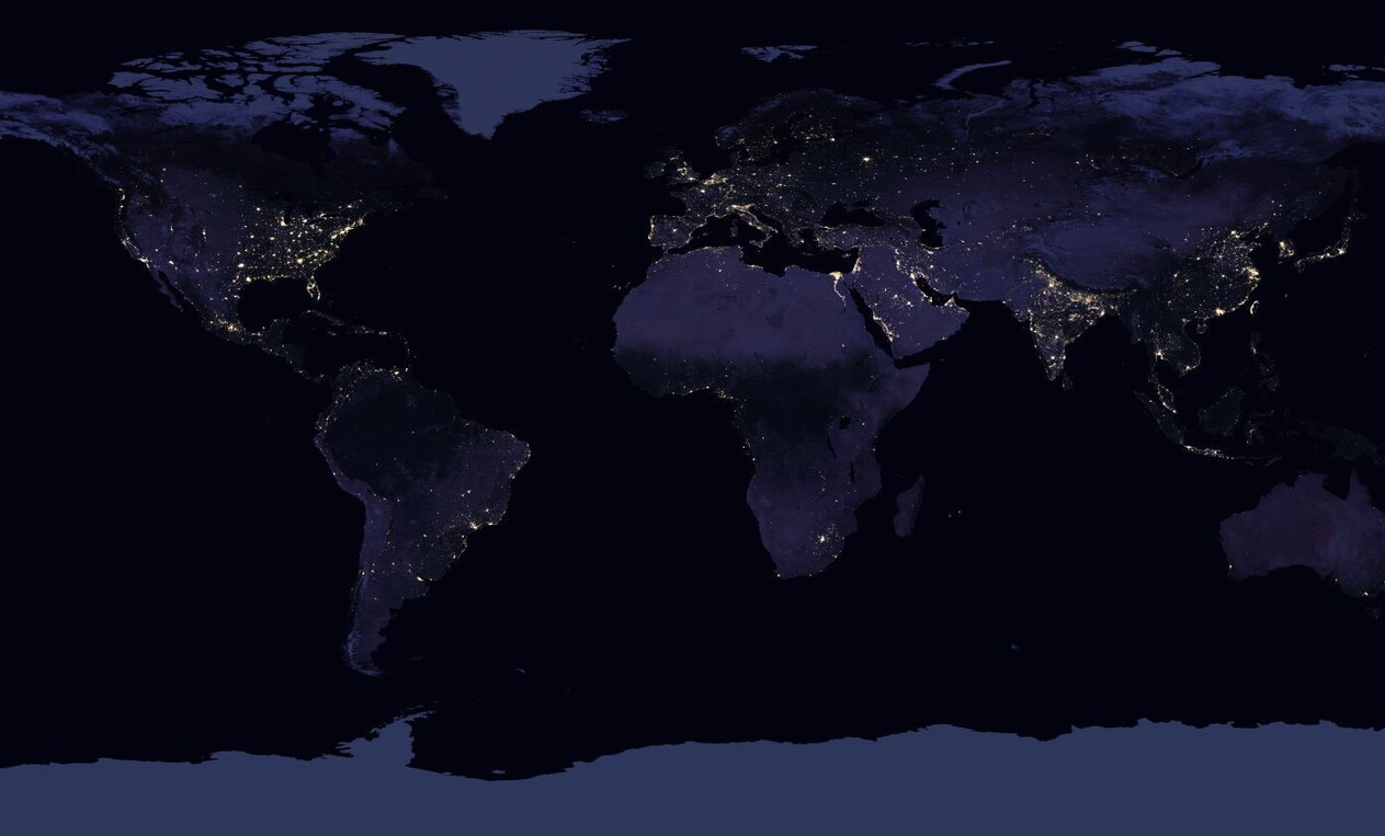
Other innovations include predictive models for mapping medium-voltage (MV) infrastructure using publicly available data, such as nighttime radiance collected by the Visible Infrared Imaging Radiometer Suite’s (VIIRS) Day-Night Band (DNB) sensor. By feeding this data into grid estimation algorithms, researchers have shown promise in predicting existing grid coverage. The University of Michigan's High Resolution Electricity Access (HREA) project has also assessed power supply reliability by comparing radiance levels at the same location over multiple nights throughout the year.
Global resources like the Solar and Wind Atlas offer downloadable maps and data on solar and wind power potential at a 1 km resolution. Ongoing efforts are focused on creating similar datasets for hydro and geothermal resources, as well as for deposits of minerals essential to the clean energy transition—an important revenue source for many African countries.

P
lanners are increasingly leveraging these datasets in GIS-based models to identify the most cost-effective strategies for achieving universal electricity access. One of the leading tools in this space is the Open Source Spatial Electrification Tool (OnSSET), developed by KTH Royal Institute of Technology. Institutions like the World Bank, through its Global Electrification Platform, and the IEA use OnSSET to model electrification scenarios for countries that still lack universal access. Complementing OnSSET is the GISEle model, developed by Politecnico di Milano, which provides detailed estimates of distribution grid topology, down to the last mile and individual pole level.
This is just a brief overview of how GIS, AI, and HPC are transforming energy planning. For a more complete picture, the IEA has compiled a comprehensive repository of datasets and models in the Africa GIS Catalogue for Energy Planning. This centralized resource offers stakeholders detailed information on all existing models and datasets for every country across the continent, making it an essential tool for leveraging geospatial analysis to achieve universal electricity access.
IEA’s Building-Level Electricity Access and Demand Estimation Model
Beyond comprehensive infrastructure maps, a critical gap identified by energy sector planners is the demand estimation step. Demand is a key factor in determining the optimal technology for providing electricity access to a settlement. Yet, it is often overlooked due to the lack of reliable data and the complexity of accounting for context-specific factors that influence energy needs. To address this issue, the IEA, with support from Power Africa, partnered with MIT to develop the Building-Level Electricity Access and Demand Estimation model—a significant advancement in electrification efforts.
Our model can estimate electricity demand in both electrified and yet-to-be-electrified areas by using AI trained to correlate satellite imagery and GIS data with verified electricity consumption data. By factoring in variables such as roof materials, building size, proximity to infrastructure, and internet speed as a proxy for economic activity, the model accurately predicts both current and future demand for buildings without meter data, with an error rate 40 percent lower than traditional methods. This innovation represents a major improvement in electrification planning, enabling more precise and effective energy solutions.
Bridging data gaps and enhancing accuracy
While technological advancements like GIS, AI, and HPC have greatly improved energy planning, significant challenges still remain to be addressed.
The absence of a a centralized, open-access database accessible to all stakeholders—government agencies, utilities, developers—has created significant information asymmetry. Different stakeholders have varying levels of access to critical data, which hinders coordination and slows progress toward universal electricity access. Without a unified source of validated data, the energy sector suffers from inefficiencies such as duplicated efforts and delays in planning and implementation.
Advanced technologies require significant investments in infrastructure and expertise, which can strain national budgets
This lack of consistent data coordination slows decision-making and impedes progress toward universal energy access. A comprehensive repository of unified planning data would not only streamline efforts but also improve data quality and reliability, making planning processes more efficient.
Financial constraints compound the issue. The costs of high-quality data collection, skilled personnel, and advanced computational tools are substantial, and many countries in the region lack the financial capacity to sustain these efforts independently. Advanced technologies require significant investments in infrastructure and expertise, which can strain national budgets. International partnerships, financial support, and targeted investments are essential to overcoming these challenges. Without sufficient funding, both technological solutions and the on-the-ground initiatives they support risk stalling, severely limiting the ability to scale energy access across underserved regions.

T
o fully capitalize on the potential of these tools, building local capacity is crucial. Many countries face not only financial but also technical limitations, making it difficult to effectively utilize GIS, AI, and HPC tools without external support. By investing in education and training, governments and organizations can empower local experts to take the lead in energy planning. Integrating these technological skills into educational curricula will equip the next generation of planners, while workshops and training programs can upskill current professionals in government agencies, utilities, and local development firms.
Localizing technical expertise is not just about reducing reliance on external consultants; it’s about ensuring that energy solutions are tailored to the unique needs and conditions of each region. By equipping local planners with the necessary skills and tools, countries can promote long-term sustainability in energy planning. Additionally, these efforts create a stronger foundation for future innovation, as local experts will be able to adapt and refine global tools to better serve their communities.
Conclusions
Achieving universal electricity access by 2030 is not only ambitious but essential. Electricity is a key driver of economic development, powering vital services like healthcare and education and helping to lift communities out of poverty. While advanced technologies like GIS, AI, and HPC hold great promise, they are not a panacea for achieving universal access. These tools can greatly enhance data analysis and planning, but they cannot fully replace the field surveys, community engagement, and ground-truthing necessary to ensure plans are accurate and contextually appropriate. Tools like the IEA's building-level model are revolutionizing energy planning by directing efforts where they are most needed, optimizing resources, and accelerating progress. However, lasting success depends on combining these technological innovations with traditional, on-the-ground methods. Empowering local stakeholders with the skills to use these tools is crucial for sustaining progress and building a more equitable, prosperous future for millions across Africa.

